
7 Mountain Hikes with Suspension Bridges in South Korea
Discover seven rewarding Korean mountain hikes where suspension bridges meet rocky ridges, temple scenery and island sea views — with summit heights, route ideas and practical difficulty notes.
October 1, 2026 · TAGY Outdoor · 19 views
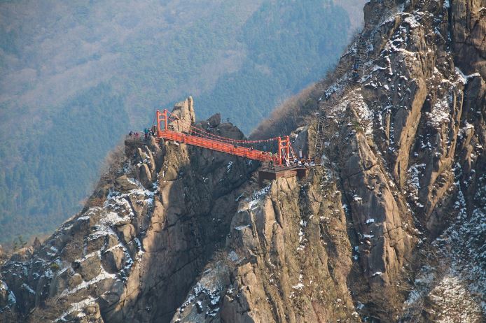
Some of Korea’s most memorable bridge crossings come after an uphill walk: forest gives way to rock, the ridge opens, and a narrow bridge stretches between cliffs. The reward is the whole mountain around it — the climb, the changing views and the sense of moving through a landscape.
For this TAGY Outdoor selection, we chose seven mountain hikes where a bridge forms part of a rewarding trail. These are route ideas for hikers, with summit options clearly distinguished from shorter bridge walks.
Planning note: Summit elevations are above sea level, not elevation gain. Times below are approximate planning allowances for the named routes, not guaranteed schedules. Difficulty ratings are TAGY editorial assessments of the terrain, steepness and exposure in dry conditions. Trail variants, breaks and weather change the total distance and time. We have not assigned elevation-gain figures without a verified track.
1. Unaksan, Pocheon — A Cliffside Cloud Trail
Summit: approximately 938 m
Location: Pocheon–Gapyeong boundary, Gyeonggi-do
Bridge setting: Pocheon-side Unaksan Gureumgil, around 800 m above sea level
Suggested route: Unaksan Plaza → waterfall viewpoint → Aegibong → cloud bridge and cliff walkway → Seobong → Dongbong → Unaksa → starting point
Allow: approximately 5–6 hours for a full mountain circuit
Difficulty: challenging; previous mountain hiking experience recommended
Unaksan is an appealing choice for hikers based in Seoul who want dramatic rocky scenery. On the Pocheon side, the cloud trail brings the route onto a high cliff face, combining a suspension crossing with a walkway attached to the rock. It is a mountain outing that deserves a full day, good footwear and unhurried pacing.
The new cloud trail opened on September 7, 2026. Do not confuse it with the separate, lower bridge on the Gapyeong side. The approach includes demanding mountain terrain; the bridge itself does not make the complete hike suitable for beginners.
Opening report and terrain notes · Example full circuit

2. Gubongsan, Jinan — Across the Nine Peaks
Summit: 1,002 m
Location: Jinan, Jeonbuk
Bridge: approximately 100 m between the fourth and fifth peaks
Suggested route: Gubongsan parking area → peaks 1–4 → bridge → peaks 5–8 → Donnaemijae → ninth peak → Barangjae → parking area
Allow: approximately 5–6 hours for the summit circuit
Difficulty: challenging, with repeated climbs and steep steps
Gubongsan offers a satisfying sequence of rocky summits rather than a single steady ascent. The bridge joins two of the lower peaks, with views opening across the surrounding highlands. Continue toward the ninth peak and the outing becomes a more substantial test of endurance.
The crossing is an excellent focal point, but the mountain’s appeal lies in the succession of ridges and viewpoints around it. Reaching the bridge and completing all nine peaks are different commitments: plan the summit extension around the group’s fitness.
Jinan tourism information · Summit circuit timing

3. Cheongnyangsan, Bonghwa — A Bridge Above a Mountain Temple
Summit: Janginbong, 870 m
Location: Bonghwa, Gyeongsangbuk-do
Bridge: Haneuldari, approximately 90 m long, connecting Jaranbong and Seonhakbong
Suggested route: Ipseok → Cheongnyangsa → Dwitsil Pass → Haneuldari → Janginbong → Cheongnyang Waterfall
Allow: approximately 3–4 hours; arrange transport between the different trail ends
Difficulty: moderate to challenging, with sustained uphill sections and stairs
Cheongnyangsan combines a mountain temple, forested slopes and striking rock formations. Walking up through Cheongnyangsa gives the outing a cultural dimension before the route reaches the high bridge and summit.
The bridge sits around 800 m above sea level, placing the crossing within the mountain’s upper terrain. This is a good choice for travelers who enjoy both hiking and the atmosphere of a Korean temple, and can comfortably manage steep stairs.
Bonghwa official facilities information · Official trail options

4. Baegasan, Hwasun — Pale Rocks and a High Ridge Crossing
Summit: approximately 810 m
Location: Hwasun, Jeollanam-do
Bridge: Haneuldari, approximately 66 m long, between Madangbawi and Jeolteobawi
Suggested route: Baegasan Tourist Ranch trailhead → Haneuldari and Madangbawi → Cheonbulbong → summit → return
Distance: roughly 6.5–7 km, depending on the selected approach
Allow: approximately 3–4 hours
Difficulty: moderate to challenging; steep approach and rocky summit sections
Baegasan’s pale rock outcrops stand above the forest, making the ridge feel surprisingly dramatic for a mountain of this height. The bridge crosses between rocks at approximately 756 m above sea level, while the wider outing adds forest trails and open viewpoints.
The tourist ranch is the trailhead, not the mountain experience itself. Hikers still need to climb to reach the crossing and continue carefully over steps and uneven rock toward the summit.
Hwasun official bridge information · Korea Tourism Organization route description

5. Wolchulsan, Yeongam — A Bridge Among Granite Towers
Summit: Cheonhwangbong, 809 m
Location: Yeongam and Gangjin, Jeollanam-do
Bridge: Gureumdari, set between granite cliffs
Shorter route: Cheonhwang district → Cheonhwangsa → bridge → return on an open designated trail
Allow: approximately 2.5–3 hours for a bridge-focused outing
Summit option: a longer route continuing toward Cheonhwangbong, generally requiring approximately 5–6 hours for a full circuit
Difficulty: moderate for the bridge outing; challenging for a summit circuit
Wolchulsan rises sharply above the surrounding countryside. Its granite towers give the hike a scale and intensity that the summit elevation alone does not suggest. The bridge is a memorable crossing framed by rock, with the climb itself forming an essential part of the experience.
A bridge visit and a summit hike should be planned separately. The short option still involves climbing and steps; continuing higher adds substantial effort. Check the national park’s current route controls before deciding on a circuit.
 National park trail information · Explore TAGY’s Southwest Korea journey
6. Daedunsan, Wanju — The Classic Rocky Mountain Crossing
Summit: Macheondae, 878 m
Location: Wanju, on the Jeonbuk–Chungcheongnam-do boundary
Bridge: Geumgang Gureumdari, approximately 48 m after reconstruction
Suggested hiking route: Wanju-side park entrance → Geumgangmun → bridge → summit approach → Macheondae → designated descent
Allow: approximately 3–4 hours on foot, with additional time for crowds
Difficulty: moderate to challenging; steep stone steps and exposed structures
Daedunsan belongs on this list when experienced as a mountain hike. Its bridge sits among striking rock pillars on the approach to Macheondae, and the walk from the foot of the mountain gives the crossing a rewarding context.
A cable car also serves the mountain, so it attracts sightseeing visitors as well as hikers. For an outdoor itinerary, choose the walking ascent and summit route. The steep Samseon stairway is a separate structure and should not be confused with the suspension bridge; use an appropriate alternative where available.

Daedunsan, photographed in March 2016, before the bridge reconstruction. Photograph by Sarang (사랑), Wikimedia Commons, public domain.

Wanju mountain and hiking routes · Bridge reconstruction details
7. Saryangdo, Tongyeong — Rocky Ridges Above the Sea
Mountain: island Jirisan, approximately 399 m; the traverse also crosses the Dalbawi area
Location: Saryangdo Island, Tongyeong, Gyeongsangnam-do
Bridges: two crossings near the Hyangbong–Yeonjibong section on the way to Oknyeobong
Suggested route: Suudo viewpoint → Jirisan → Dalbawi or suitable bypass → Gamabong → bridges → Oknyeobong → Geumpyeong ferry area
Distance: approximately 6 km
Allow: approximately 4.5–5.5 hours, plus ferry travel
Difficulty: challenging despite the low elevation; exposed rock and steep stairs
Saryangdo adds a completely different setting: an island ridge with sea views. The bridges link rocky pinnacles late in the traverse, making them part of a mountain journey rather than an isolated stop.
This island’s Jirisan is different from the mainland Jirisan National Park. Its modest height can be misleading: exposed terrain, wind and steep descents require experience and care. A regional overnight stay is more practical than a rushed day trip from Seoul.
Detailed ridge route and bridge information

Which Hike Fits Your Journey?
For a mountain day from Seoul: start by considering Unaksan, provided the group is comfortable with demanding terrain.
For repeated peaks and a substantial climb: Gubongsan offers a rewarding full summit circuit.
For temple culture and mountain scenery: Cheongnyangsan brings both into one outing.
For a southwest Korea itinerary: Baegasan and Wolchulsan work well as regional hiking days.
For classic rocky scenery: choose Daedunsan’s walking ascent rather than planning only a cable-car visit.
For sea views and an adventurous ridge: consider Saryangdo with enough time for ferries and the full traverse.
These are editorial suggestions, not a claim that every route is currently operating as a scheduled TAGY tour.
Before You Set Out
Wear hiking footwear with good grip, carry water and a windproof layer, and leave sufficient daylight for descent. Exposed bridges and rocky trails can close because of wind, weather or maintenance. Check the relevant park or local authority before departure, and choose a shorter route if the group is uncomfortable with heights.
Low elevation does not automatically mean an easy hike. Repeated climbs, steep stairs and exposed ridges matter as much as the summit height.
Tell TAGY Outdoor your travel dates, hiking experience and preferred region. We can discuss a private mountain itinerary suited to your group.
Research checked October 2, 2026 (Korea time). Sources are linked beside each destination. This article is a planning introduction, not a turn-by-turn navigation guide. Cover photograph: Wolchulsan suspension bridge, from TAGY’s existing tour collection.
Plan a Korea hiking and culture itinerary
Use the difficulty notes above to narrow your choices, then contact TAGY Travel Korea to discuss suitable trails and travel arrangements. Our private Korea tours provide ideas for combining mountain scenery with cultural visits.
Related Korea travel stories
For a day trip from Seoul that combines Gamaksan Suspension Bridge with DMZ landmarks and British military heritage, see our private DMZ and Gloucester (Gloster) Hill Memorial tour. DMZ visits depend on access conditions.